


Ph.D. architecture students create physical, digital models of campus
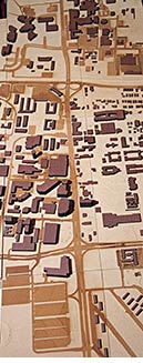 University Drive corridor on scale model of Texas A&M campus.
Detailed physical and digital models of Texas A&M’s campus were created this spring by [Ph.D. architecture] (http://dept.arch.tamu.edu/graduate/phd/) students to support graduate and undergraduate design projects, including a recent student effort aimed at reimagining the University Avenue corridor.
Students Mohammad Asl, Jawad Tabatabaie, Chengde Wu and Saied Zarrinmehr designed the campus model during the 2012-13 winter break and fabricated hundreds of individual components parts at the College of Architecture's Digital Fabrication Facility, located at Texas A&M's Riverside Campus.
The data used to construct the model was also used to create a 3-D building information model simulation of the campus.
Both models were used during the first week of the spring 2013 semester to inform the Department of Landscape Architecture and Urban Planning’s [Design Week] (http://one.arch.tamu.edu/news/2013/1/15/design-week-release/) project, which yielded numerous student-created concepts for a redesigned University Avenue corridor.
“It is immensely gratifying to work with such dedicated and skilled individuals who can turn a shared vision into a completed work of great beauty and significance,” said Mark Clayton, the professor of architecture who advised the model builders.
To produce the models, the design team processed geographic information system data, obtained from the city of College Station, into AutoCAD, Rhino, building information modeling software and several other computer programs, said Clayton.
Referencing the digital model, college staff at the Digital Fabrication Facility used a CNC router to carve the layout on medium-density fiberboard. Contributing staffers Dustin Adler and Ben Wilde were guided through the project by Chuck Tedrick, the college's digital fabrications manager.
The building models were cut from hardboard using the facility’s laser cutters and positioned according to GIS data. Duplicate footprints were cut to permit stacking to achieve models of the correct height.
“Special attention was required to create the stepped form of Kyle Field,” said Clayton.
After the fiberboard panels were mounted on wooden frames, the buildings were glued into place and the panels bolted together for the finished model; work on additional panels showing land near University Drive is under way.
Additionally, Revit software was used to develop the BIM simulations for viewing in the Department of Construction Science's computer-aided visualization environment, or [BIM CAVE] (http://one.arch.tamu.edu/news/2011/10/6/bim-cave-opening/) .
The technology allowed designers to take a virtual walk or flight through the University Drive corridor, said Clayton.
The project illustrates how BIM can be used as a central source serving many kinds of analysis and production including 2-D drawings, 3-D models, and digital fabrication, said Clayton.
The BIM model, he said, can also be used to inform economic and energy analyses, renewable energy production, rainwater capture, facility management and other forms of analysis.
Tags
Related Posts

Innovative ‘green’ wall features sheet metal, native plants

Energy Systems Lab has new location

CHC documenting Alamo's evolution
Follow Us
Facebook Twitter Vimeo Youtube Flickr RSS
Recent Posts


Planning prof heads study of disaster housing aid

A message from the dean


_thumbnail_small.png)

Former student remembered as expert planner


Leading educator named new head of Architecture Dept.
